
-
Original Article
-
Assessment of Failure Characteristics in Slopes
비탈면의 붕괴 특성 평가
-
Jungku Kim, Jinhwan Shin, Wooseok Bae
김정구, 신진환, 배우석
- Slope failure is influenced by various factors such as rock type, geology, topography, engineering properties, construction conditions of the slope, weathering rate, …
비탈면의 붕괴는 암종과 지질, 지형 및 공학적 성질, 비탈면의 시공상황, 풍화속도, 주변여건, 기후 등 다양한 요인에 영향을 받으므로 재해 예측하고및 예방을 위해서는 …
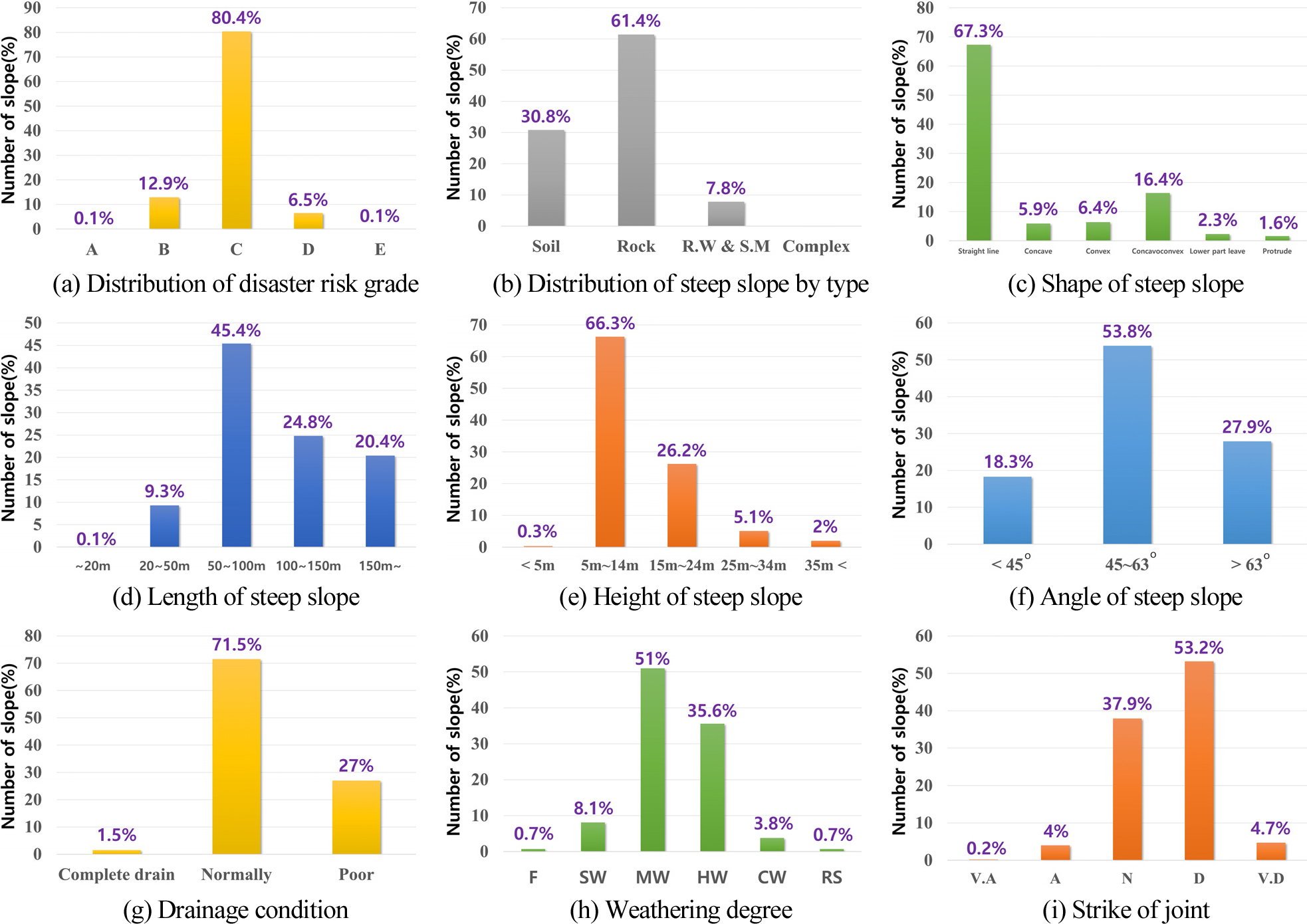
- Slope failure is influenced by various factors such as rock type, geology, topography, engineering properties, construction conditions of the slope, weathering rate, surrounding environment, and climate. Therefore, in order to predict and prevent disasters, it is necessary to evaluate the factors that may affect slope stability and manage them proactively in advance. Despite the recent increase in the frequency and scale of slope failures, precise evaluations of failed slopes remain insufficient. In particular, the absence of systematic investigations into failure sites has hindered data collection on disaster characteristics, thereby limiting further research. In this study, field surveys were conducted on 160 failed slopes, and the findings were analyzed and compared with data from 7,791 non-failed slopes alongside various previous research results. The analysis revealed distinct differences between failed and non-failed slopes in terms of gradient and cross-sectional structures. Furthermore, a close correlation was confirmed between the geological factors triggering failure and the resulting failure modes depending on the rock type. Consequently, it was determined that the characteristics of geological discontinuities for each rock type must be rigorously considered during stability assessments. These findings suggest that the results should be fed back into investigation manuals to allow for more detailed classification and subdivision of survey items for enhanced failure prediction.
- COLLAPSE
비탈면의 붕괴는 암종과 지질, 지형 및 공학적 성질, 비탈면의 시공상황, 풍화속도, 주변여건, 기후 등 다양한 요인에 영향을 받으므로 재해 예측하고및 예방을 위해서는 비탈면의 안정에 영향을 줄 수 있는 인자를 평가하고 사전에 관리할 필요가 있다. 최근 비탈면 붕괴는 매년 증가하고 대형화되고 있으나 붕괴 비탈면에 대한 정밀한 평가는 부족한 상황이며, 특히 체계화된 붕괴지 조사의 부재로 재해특성에 대한 자료화가 충분하지 못해 추가적인 연구에 한계가 있는 것으로 판단된다. 본 연구에서는 붕괴가 발생된 160개 비탈면을 대상으로 현장조사를 수행하고 조사내용을 분석하였으며 7,791개소의 미붕괴 비탈면 자료 및 다수의 연구결과와 비교하였다. 연구결과 미붕괴 비탈면과 경사나 횡단구조에서 차별성을 나타내고 암종에 따라 붕괴를 유발하는 지질학적 요인과 그로 인한 파괴형태가 밀접한 연관성이 있음이 확인되어 안정성 검토 시 암종별로 지질학적 불연속면의 특성을 반드시 고려해야 하는 것으로 분석되었다. 이러한 분석결과를 통해 붕괴예측을 위해 조사항목을 세분화하여 분류할 수 있도록 조사 매뉴얼의 환류가 필요하다.
-
Assessment of Failure Characteristics in Slopes
-
Original Article
-
Prediction of Future Land Cover Change Using MOLUSCE
MOLUSCE 기반 미래 토지피복 변화 예측
-
Hyung-Joon Chang, Yong-Soo Cho
장형준, 조용수
- Land cover change is a key factor affecting watershed environments and spatial structures as a result of urbanization and land-use change. This …
토지피복 변화는 도시화 및 토지 이용 변화에 따라 지속적으로 발생하며, 유역의 공간구조와 환경 특성에 영향을 미치는 중요한 요소이다. 본 연구에서는 대전광역시 갑천 …
- Land cover change is a key factor affecting watershed environments and spatial structures as a result of urbanization and land-use change. This study applied the MOLUSCE (Module for Land Use Change Simulation) model to predict future land cover changes in the Gasuwongyo watershed located in the Gapcheon basin, Daejeon, Republic of Korea. Land cover maps for the 2000s, 2010s, and 2020s were collected from the Environmental Geographic Information Service (EGIS), and temporal land cover changes were analyzed. The applicability of the model was evaluated by simulating the land cover map for the 2020s using data from the 2000s and 2010s and comparing the results with the observed land cover map. Subsequently, the validated model was used to generate a future land cover map for the 2030s. The results indicated that urban areas are expected to increase continuously, while agricultural areas are likely to decrease. Forest areas remained the dominant land cover type within the watershed. The predicted land cover map developed in this study can serve as a useful dataset for future land-use planning and watershed management studies.
- COLLAPSE
토지피복 변화는 도시화 및 토지 이용 변화에 따라 지속적으로 발생하며, 유역의 공간구조와 환경 특성에 영향을 미치는 중요한 요소이다. 본 연구에서는 대전광역시 갑천 수계에 위치한 가수원교 유역을 대상으로 미래 토지피복 변화를 예측하기 위하여 MOLUSCE(Module for Land Use Change Simulation) 모형을 적용하였다. 환경부 환경공간정보서비스에서 제공하는 2000년대, 2010년대 및 2020년대 토지피복도 자료를 구축하고, 연대별 토지피복 변화 특성을 분석하였다. 또한 2000년대와 2010년대 토지피복 자료를 활용하여 2020년대 토지피복도를 모의하고 실제 토지피복도와 비교하여 모형의 적용성을 검토하였다. 이후 검증된 모형을 이용하여 2030년대 토지피복도를 구축하였다. 분석 결과 시가화지역은 지속적으로 증가하는 반면 농업지역은 감소하는 경향을 나타내었으며, 산림지역은 연구유역의 주요 토지피복 유형으로 유지되는 것으로 분석되었다. 본 연구에서 구축한 미래 토지피복도는 향후 토지 이용 변화 분석 및 유역 관리 연구를 위한 기초자료로 활용될 수 있을 것으로 판단된다.
-
Prediction of Future Land Cover Change Using MOLUSCE
-
Original Article
-
Applicability Evaluation of the HEC-HMS Rainfall-Runoff Model for the Jungbangdaecheon Basin
중방대천 유역을 대상으로 한 HEC-HMS 강우-유출 모형의 적용성 평가
-
Seong-Goo Kim, Yong-Soo Cho
김성구, 조용수
- The increasing frequency of localized heavy rainfall and flash floods due to climate change has highlighted the need for accurate flood estimation …
최근 기후변화로 인해 국지성 집중호우와 돌발홍수의 발생 빈도가 증가하면서 소규모 산지유역에 대한 정확한 홍수량 산정의 중요성이 커지고 있다. 본 연구에서는 강원특별자치도 홍천군에 …
- The increasing frequency of localized heavy rainfall and flash floods due to climate change has highlighted the need for accurate flood estimation in small mountainous watersheds. This study developed a HEC-HMS rainfall-runoff model for the Jungbangdaecheon Basin located in Hongcheon-gun, Gangwon State, South Korea, and evaluated the applicability of the empirical equations developed by Seokyeong University and recommended in the Korean Flood Estimation Guidelines. Hydrologic parameters, including the SCS Curve Number (CN), time of concentration (Tc), and storage coefficient (K), were estimated through watershed characteristic analysis, and the model was constructed using observed rainfall-runoff events from 2014 to 2021. In addition, parameter optimization was performed for the Clark Unit Hydrograph method, and model performance was evaluated using the Nash-Sutcliffe Efficiency (NSE). The results showed that some rainfall-runoff events exhibited relatively low simulation accuracy when the initial parameters were applied; however, NSE values improved for most events after parameter optimization. The findings indicate that the empirical equations developed by Seokyeong University can be applied to small mountainous watersheds. However, calibration using observed data is necessary to improve the accuracy of flood estimation.
- COLLAPSE
최근 기후변화로 인해 국지성 집중호우와 돌발홍수의 발생 빈도가 증가하면서 소규모 산지유역에 대한 정확한 홍수량 산정의 중요성이 커지고 있다. 본 연구에서는 강원특별자치도 홍천군에 위치한 중방대천 유역을 대상으로 HEC-HMS 강우-유출 모형을 구축하고, 홍수량 산정 표준지침에서 제시하는 서경대학교 경험공식의 적용성을 검토하였다. 유역 특성 분석을 통해 SCS-CN, 도달시간(Tc), 저류상수(K)를 산정하였으며, 2014년부터 2021년까지의 강우-유출 사상을 이용하여 모형을 구축하였다. 또한 Clark 단위도법의 주요 매개변수에 대한 최적화를 수행하고 Nash-Sutcliffe Efficiency(NSE)를 이용하여 모형의 재현성을 평가하였다. 분석 결과 초기 매개변수를 적용한 경우 일부 강우사상에서 낮은 모의 정확도를 보였으나, 최적화 수행 후 대부분의 강우사상에서 NSE가 향상되었다. 연구 결과 서경대학교 경험공식은 소규모 산지유역에 적용 가능성이 있는 것으로 나타났으며, 보다 정확한 홍수량 산정을 위해서는 관측자료를 활용한 매개변수 보정이 필요한 것으로 판단된다.
-
Applicability Evaluation of the HEC-HMS Rainfall-Runoff Model for the Jungbangdaecheon Basin
-
Original Article
-
Flood Risk Analysis and Development of Stage-Based Alarm Levels in the Majalaya Area of the Upper Citarum River
찌따룸 강 상류 Majalaya 지역의 홍수위험도 분석을 통한 단계별 경보수위 설정 연구
-
Sung Soo Lee, Kye Won Jun, Tae Jung Jung, Seung Ryong Yang
이성수, 전계원, 정태정, 양승룡
- This study aims to quantitatively assess flood risk in the Majalaya area of the upper Citarum River basin, Indonesia, and to establish …
본 연구는 인도네시아 찌따룸 강 상류 Majalaya 지역을 대상으로 홍수위험도를 정량적으로 분석하고, 이를 기반으로 단계별 경보수위 및 대피기준을 설정하는 것을 목적으로 한다. …
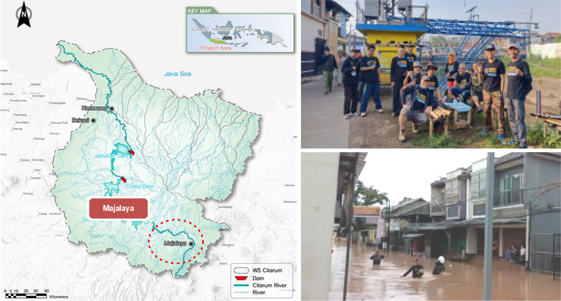
- This study aims to quantitatively assess flood risk in the Majalaya area of the upper Citarum River basin, Indonesia, and to establish stage-based alarm levels and evacuation criteria. The flood risk analysis was conducted by integrating the HEC-HMS rainfall-runoff model and the HEC-RAS 2D hydraulic model to calculate the inundation depth and area by return period, thereby quantifying the risk for each stage. The HEC-HMS model estimated design discharges for return periods of 2, 25, 50, and 100 years by applying Log-Pearson Type III frequency analysis and the Huff fourth-quartile temporal distribution. Concurrently, the HEC-RAS 2D model simulated the inundation extent, depth, and velocity through the numerical analysis of two-dimensional unsteady continuity and momentum equations. The simulation results revealed that the inundated area expanded approximately 9.5-fold, from 163.59 ha for the 2-year return period to 1,550.15 ha for the 100-year return period, while the mean inundation depth increased from 1.2 m to 2.1 m. Based on a comparative analysis of the Indonesian PUPR guidelines, the Rating Curve methodology, and the Korean flood warning criteria, the levee-height ratio approach (Option 2) was selected as the optimal alternative due to its superior reflection of local hydrological characteristics and suitability for the CBDRM framework. By applying this selected option, a three-stage alarm system consisting of GREEN (Caution), YELLOW (Alert), and RED (Danger) levels was established. Furthermore, this system was compared and analyzed against Korea’s four-stage flood warning system (Attention, Caution, Alert, and Serious) to ensure its effective application as a reliable basis for CBDRM action plans.
- COLLAPSE
본 연구는 인도네시아 찌따룸 강 상류 Majalaya 지역을 대상으로 홍수위험도를 정량적으로 분석하고, 이를 기반으로 단계별 경보수위 및 대피기준을 설정하는 것을 목적으로 한다. 홍수위험도 분석은 HEC-HMS 강우-유출 모형과 HEC-RAS 2D 수리 모형을 통합 적용하여 재현빈도별 침수심 및 침수면적을 산정하고, 이로부터 단계별 위험도를 정량화하는 방식으로 수행하였다. HEC-HMS 모형은 Log-Pearson Type III 빈도분석과 Huff 4분위 시간분포를 적용하여 2년·25년·50년·100년 재현빈도별 설계홍수량을 산출하였으며, HEC-RAS 2D 모형은 2차원 비정상류 연속 방정식과 운동량 방정식을 수치 해석하여 침수범위·침수심·유속을 모의하였다. 침수면적은 2년 빈도 163.59 ha에서 100년 빈도 1,550.15 ha로 약 9.5배 확대되었으며, 평균 침수심은 1.2 m에서 2.1 m로 증가하였다. 인도네시아 PUPR 지침, Rating Curve 기반 기준, 한국의 홍수경보 기준을 비교 분석한 결과, 제방고 비율 기반 옵션2을 지역 수문 특성 및 CBDRM 적합성 측면에서 최적안으로 선정하었다. 이를 적용하여 GREEN(주의)·YELLOW(경계)·RED(위험) 3단계 경보수위를 수립하고, 한국의 관심·주의·경계·심각 4단계 홍수경보 체계와 비교 분석하여 CBDRM 실행계획에 근거로 활용될 수 있도록 하였다.
-
Flood Risk Analysis and Development of Stage-Based Alarm Levels in the Majalaya Area of the Upper Citarum River
-
Original Article
-
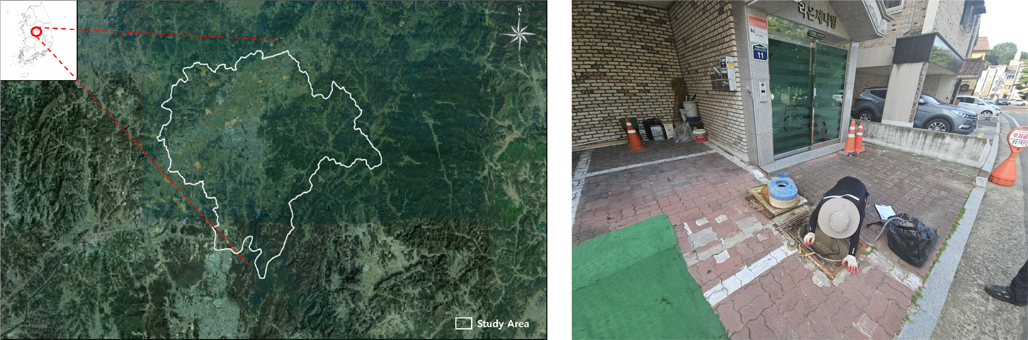
Estimation of Appropriate Labor Requirements through Analysis of Work Characteristics in Water Meter Replacement Processes
수도계량기 교체공정의 작업특성 분석을 통한 적정 공수 산정
-
Hyung-Joon Chang, Yong-Soo Cho, Ho-Jin Lee
장형준, 조용수, 이호진
- This study analyzed the work characteristics of water meter replacement projects in Cheongju City using field surveys and replacement records. A total …
본 연구에서는 청주시 수도계량기 교체사업을 대상으로 현장조사 및 교체실적 자료를 활용하여 계량기 구경, 연결방식 및 작업환경에 따른 작업특성을 분석하였다. 총 683건의 교체자료를 …
- This study analyzed the work characteristics of water meter replacement projects in Cheongju City using field surveys and replacement records. A total of 683 replacement cases were collected and evaluated to investigate the effects of meter diameter, connection type, and installation environment on replacement time. The results showed that replacement time increased with meter diameter and that flange-type meters required longer replacement times than union-type meters. In addition, work productivity varied according to installation environment, including apartment complexes, urban residential areas, and rural/commercial areas. The findings indicate that labor requirements should consider not only meter diameter but also connection type and auxiliary work such as strainer replacement. The results provide useful reference data for labor estimation and cost calculation in water meter replacement projects.
- COLLAPSE
본 연구에서는 청주시 수도계량기 교체사업을 대상으로 현장조사 및 교체실적 자료를 활용하여 계량기 구경, 연결방식 및 작업환경에 따른 작업특성을 분석하였다. 총 683건의 교체자료를 분석한 결과, 계량기 구경이 증가할수록 교체시간이 증가하는 경향을 나타냈으며, 동일 구경에서도 플랜지형 계량기가 유니온형 계량기보다 더 긴 작업시간을 보였다. 또한 아파트, 도심지 및 교외지역 등 설치환경에 따라 교체시간의 차이가 발생하는 것으로 나타났다. 특히 플랜지형 계량기의 경우 스트레이너 교체 등 부대작업이 함께 수행되어 공수 증가에 영향을 미치는 것으로 분석되었다. 연구 결과는 수도계량기 교체사업의 적정 공수 산정 및 예정가격 산정의 기초자료로 활용될 수 있을 것으로 판단된다.
-
Estimation of Appropriate Labor Requirements through Analysis of Work Characteristics in Water Meter Replacement Processes

Journal Informaiton
 Journal of Korean Society of Disaster and Security
Journal of Korean Society of Disaster and Security


한국방재안전학회
Room 210, 2F, Engineering Building II, KNU Samcheok Campus, 346 Jungang-ro, Samcheok-si, Gangwon-do, 25913 Republic of Korea
Tel: +82-2-720-3406 / E-mail: kor3s@daum.net Copyright© Korean Society of Disaster and Security. Powered by APUB
Tel: +82-2-720-3406 / E-mail: kor3s@daum.net Copyright© Korean Society of Disaster and Security. Powered by APUB